
With 96% of the Canadian population living at or south of Edmonton’s latitude, we utilized a new data source to build a combined USA/Canada digital map.
This map was created for companies requiring at-a-glance comprehension of facilities, customers, or transportation logistics—in both countries. (Of course, we can import your addresses of locations for both countries.) Remember, the map is completely editable in Adobe Illustrator.
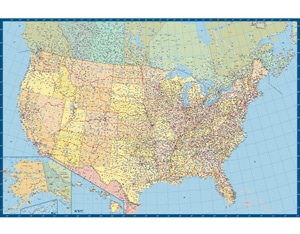
At scale, the smallest we can print this wall map, with all layers on, is 89″ wide by 59″ tall (150 cm by 226 cm). This high-resolution vector map supports even larger wall map sizes.
Clean international border, US states/Canadian provinces crisply delineated, and everything else you’d expect from Creative Force Custom Map Department’s philosophy of just enough information and low visual map noise.
The USA/Canadian border is the longest non-militarized border in the world, and Canada boasts the longest coastline of any country—oh, how those Canadians boast about such things.
You may know that I’m from Minnesota, and while researching this blog I discovered that Minnesota’s complicated border with Canada was an error created by a cartographer getting the headwater of the Mississippi River wrong. (I’ve never made a cartographic error that bad.)
One more thing—our Head Cartographer, Dwight, is about halfway through extending the map to include all of Mexico. If you’re interested, it will be fully edited and ready to go in two weeks.

Our USA/Canada Map extended into Mexico